Our Cycling Route Through Georgia

The green line on the map above shows the exact GPS route we have cycled. The pins on the map show our final destination for each cycling day. You can click on a pin to see the date we cycled.
Our cycling route through Georgia
The map above shows the route we cycled through Georgia. We entered Georgia from it's southern boarder with Turkey and exited through the eastern border into Azerbaijan.
The roads in Georgia were nothing short of terrible. Of all the countries we’ve visited we rank Georgia as the second worse, only to Uzbekistan (Who are currently building most of their roads).
The roads were rough, damaged and in several cases made of only dirt and rock. It certainly made riding here a real challenge.
Despite the bad roads the scenery in Georgia was breath taking, our route took us through some of the best landscapes and challenges of the entire trip and we would highly recommend a cycling trip to this beautiful country.
Speaking of challenges, some other cyclists had recommended we check out the “Goderdzi Pass”. They seemed much infused about how great it was so altered our routed and headed straight for it.
We didn’t do any research anything about the Goderdzi Pass before hand, we just trusted their opinion and enthusiasm and figured everything would be fine. However, what lay ahead was far more than we could have ever imagined.
As we approached the pass the weather started to turn for the worse, a heavy mist surrounded up and everything began to get very wet. Shortly after beginning our ascent of the pass we bumped into two German cyclists who were also heading over the pass today, we got chatting with them and continued our ascent together.
After a couple of miles the tarmac abruptly ended and so started the beginning of the chaos. We assumed at this point that the missing tarmac would only be a short section, perhaps it was under construction and the rain had turned it into this heavy gloopy mud. After all, this appeared to be a well-known route and it was clearly marked on all the maps as being a “road” so this mud must be temporary. The occasional passing car also gave us hope that the road must return further up the pass.
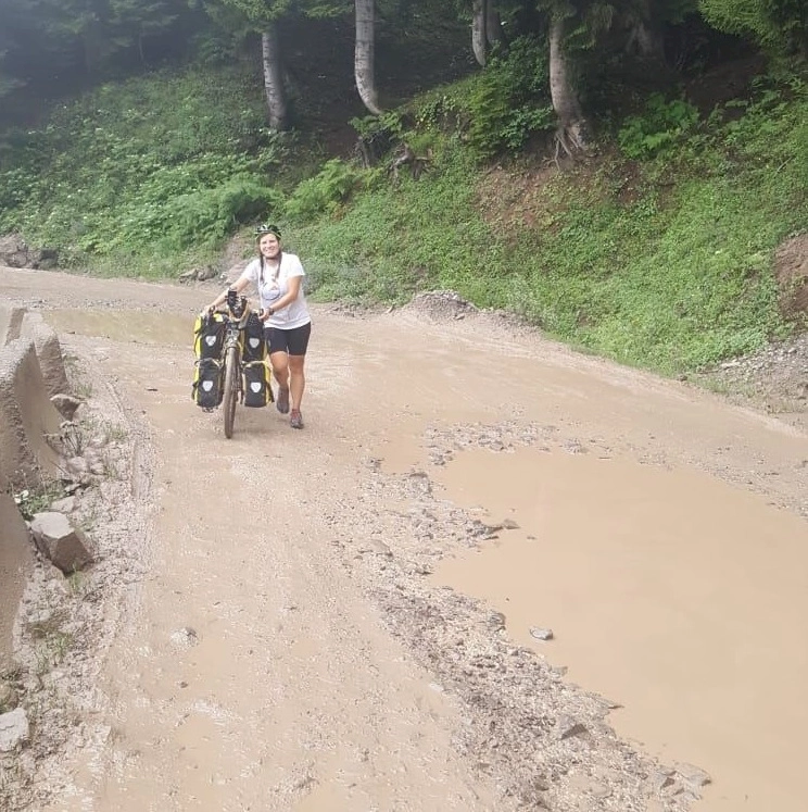
As you might have guessed by now, the road never returned. We battled on through thick gloopy mud for mile after mile with the rain and mist ever intensifying.
We were frequently stopping to clear mud out of the mudguards and often having to push because there was so little traction in the mud. After all, we had brought two road touring bike, we never intended to be riding in conditions like this and as such our bikes had tred designed to clear water not mud and out mud guard clearance is minimal to return drag.
At one point during the ascent Zoe’s real wheel became so jammed with mud it was pushed out of the frame. We had already fallen behind the German’s we were cycling with and after stopping to fix the issue with the wheel we never saw them again.

After another hour or so of riding and pushing blindly into the mist we started to get very cold and very hungry. We were soaked to the bones and everything with thick with mud, the last thing we wanted to do in these conditions was camp but it was looking like our only option.
We could see on the map the top was still a long way off and we couldn’t see anything marked on the map except for a café at the summit. We pushed on in desperation knowing that if we wanted someone warm and dry to sleep tonight we’d have to get to the top and down the other side.
But then, out of the mist emerged a tiny wooden sign that read “Hotel”. It seemed too good to be true, it was pointing off the track we were following and downhill into the misty unknown.
We needed this hotel to be real so badly, we followed the arrow down the bank and what emerged was a newly built ski resort hotel, even better it also had a café/restaurant!
We could not believe our luck! We checked in, warmed up and filled our bellies. We also have quite a nice room for the night and they even let me use their hose pipe to wash off the bikes and all of our bags.
The next morning the weather eventually cleared and we descended down the other side of the pass. The track wasn’t much better on the other side but it had at least changed from mud to rocks.
After the Goderdzi Pass we cycled some stunning roads in what I can only describe as the Georgian “highlands”, leading up to Tblisi.
After Tblisi the weather once again began warming up and the landscape became much dryer, unknown to us at the time but I clear sign of what was to come in Azerbaijan.
If you'd like to take a closer look at our route or use it for your plans you can download the .kml file using the button below. For PC users you can view this file type in "Google Earth Pro", available here: google.com/earth/versions/, for Android users we recommend maps.me and for iPhone users we also recommend maps.me.
Download our Route through GeorgiaOur cycling stats for Georgia
13.84 kmph
708.01 km
64.36 km
124.88 km
9,003 meters
2,168 meters
World Tour Stats
If you enjoyed these stats you can use the button below to see our complete statistics for the entire journey so far, along with our planned route and route taken.
View all World Tour Stats
Daily Cycling Activity
Below is a breakdown of our daily cycling activity, you can see our exact route and final destination each day using the map at the top of the page.
| Day | Start/Finish | Distance | Duration | Avg. Speed | Elevation Gained | Elevation Min/Max |
|---|---|---|---|---|---|---|
| 11 |
Mashnaari to Balaken 5th August 2019 |
36.39 miles 58.22 km |
3:50 |
9.45 mph 15.12 kmph |
1,313 ft 400 m |
682 ft / 1,485 ft 208 m / 453 m |
| 10 |
Sarajego to Mashnaari 4th August 2019 |
40.95 miles 65.52 km |
3:58 |
10.32 mph 16.51 kmph |
1,892 ft 577 m |
905 ft / 2,538 ft 276 m / 774 m |
| 9 |
Tbilisi to Sagarejo 3rd August 2019 |
30.11 miles 48.18 km |
3:39 |
8.24 mph 13.19 kmph |
2,096 ft 639 m |
1,421 ft / 2,802 ft 433 m / 854 m |
| 8 |
Tbilisi to Tbilisi - same city, different room. We are both too sick to ride! 🤢 💩 2nd August 2019 |
0.22 miles 0.35 km |
0:02 |
5.59 mph 8.95 kmph |
0 ft 0 m |
1,425 ft / 1,450 ft 434 m / 442 m |
| 7 |
Saghrasheni to Tbilisi 27th July 2019 |
29.66 miles 47.45 km |
3:13 |
9.20 mph 14.71 kmph |
1,965 ft 599 m |
1,241 ft / 2,499 ft 378 m / 762 m |
| 6 |
Ninotsminda to Saghrasheni 26th July 2019 |
77.08 miles 123.32 km |
8:09 |
9.45 mph 15.12 kmph |
4,056 ft 1,236 m |
2,209 ft / 7,114 ft 673 m / 2,168 m |
| 5 |
Akhaltsikhe to Ninotsminda 25th July 2019 |
52.23 miles 83.57 km |
6:31 |
8.01 mph 12.81 kmph |
4,684 ft 1,428 m |
3,126 ft / 6,346 ft 953 m / 1,934 m |
| 4 |
Goderdzi to Akhaltsikhe 24th July 2019 |
33.01 miles 52.82 km |
4:01 |
8.20 mph 13.12 kmph |
1,973 ft 601 m |
3,173 ft / 6,658 ft 967 m / 2,029 m |
| 3 |
Batumi to Goderdzi (ski resort) 23rd July 2019 |
13.64 miles 21.83 km |
3:05 |
4.42 mph 7.07 kmph |
3,395 ft 1,035 m |
2,413 ft / 5,631 ft 736 m / 1,716 m |
| 2 |
Batumi to Khulo 22nd July 2019 |
51.18 miles 81.88 km |
5:43 |
8.94 mph 14.30 kmph |
4,920 ft 1,500 m |
30 ft / 3,087 ft 9 m / 941 m |
| 1 |
Rize to Batumi, Georgia!!! 🇬🇪 20th July 2019 |
78.05 miles 124.88 km |
5:50 |
13.37 mph 21.39 kmph |
3,243 ft 989 m |
-37 ft / 300 ft -11 m / 91 m |
Post written by: Stewart
Comments
Ask a question or join the discussion below.
Go back to World Tour to see more content like this or checkout similar content below.
Back to World Tour
No comments have been made yet, be the first!